About the Project
In 1948 the state Division of Mines, a unit of the Department of Natural Resources, published a bulletin to commemorate the centennial of John Marshall's discovery of gold at Coloma and thus the beginning of the California Gold Rush. The Division of Mines had a long and important history of publishing treatises on mining and the mining counties, but this volume was different. Instead of providing updates on specific mines or information about the amount of gold a particular county produced in a year, this volume would different. It was intended for the pleasure of the general public.
Bulletin 141:
|
|
Bulletin 141: Geologic Guidebook along Highway 49 - Sierran Gold Belt - The Mother Lode Country was "to serve as a guide to the traveler who is desirous of information concerning the mines, minerals, and rocks of the region, as well as the old structures erected during the Gold Rush Days." The volume had 10 chapters with 10 different authors, The last chapter though is the subject of this blog.
Survey of Building Structures of the Sierran Gold Belt - 1848-70
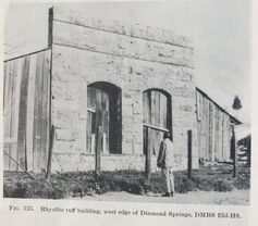
The last and largest chapter in the book, Survey of Building Structures of the Sierran Gold Belt, is a travel log along Highway 49. In early 1948, beginning in Mariposa and traveling north along the Mother Lode Highway to Downieville, archeologists Robert Heizer and Franklin Fenenga documented the still standing stone and brick buildings constructed during the 20 years after gold discovery. Heizer and Fenenga, along with their traveling companion Oliver Brown of the Division of Mines, photographed many of the building and structures that they found that had withstood the test of time.
Repeat Photography
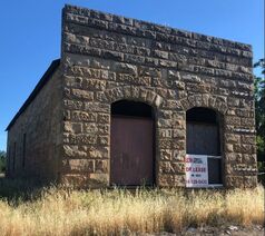
My goal is find as many of these structures that are still standing 70 years after their project and photograph them. As much as possible I have tried to stand in the same spot Heizer and Fenenga did and re-create the image as close as possible to their photograph. To find the structures I have used descriptions from the bulletin, historic maps and newspapers, Google maps, windshield surveys, web searches, and any other useful source I can find. Some buildings have proven impossible for me to find, time as taken its final tole on some, others are on private property, some are hidden by brush or have been buried, changes in highway routing have made previous descriptions meaningless. For those buildings I have found, it has been the joy of a treasure hunt. Here I hope to post the images for the various building, how I went about finding and photographing the structures, and any stories I may come across either historic or modern day that tell the story of these white whales.
