|
|
Visit Dates: May 31, 2021 & August 15, 2021
I hate trying to track down old stone and brick buildings that may or may not still exist. It drives me bonkers trying to figure out if the buildings are still standing, where they might be or where they were located, and when they may have been destroyed. I'll confess that when I can't find the structure I'm never totally confident that I've looking in the right spot. I'm pretty sure that the two buildings in this (and previous) post have been destroyed and have left no trace. Remember in grade school when you had to show your work in math class? Well, this post (and Part I) is my attempt to show my work in trying to locate these buildings and also explain what may have happened to them.
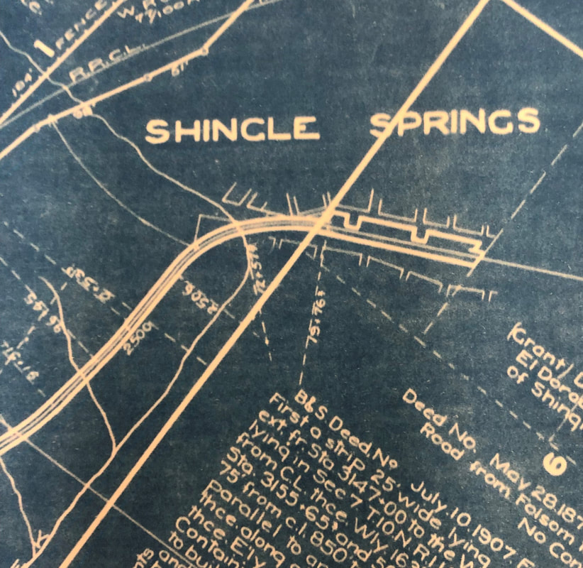
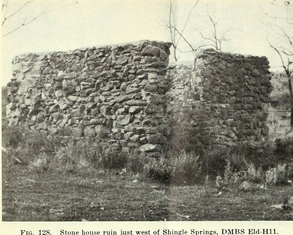
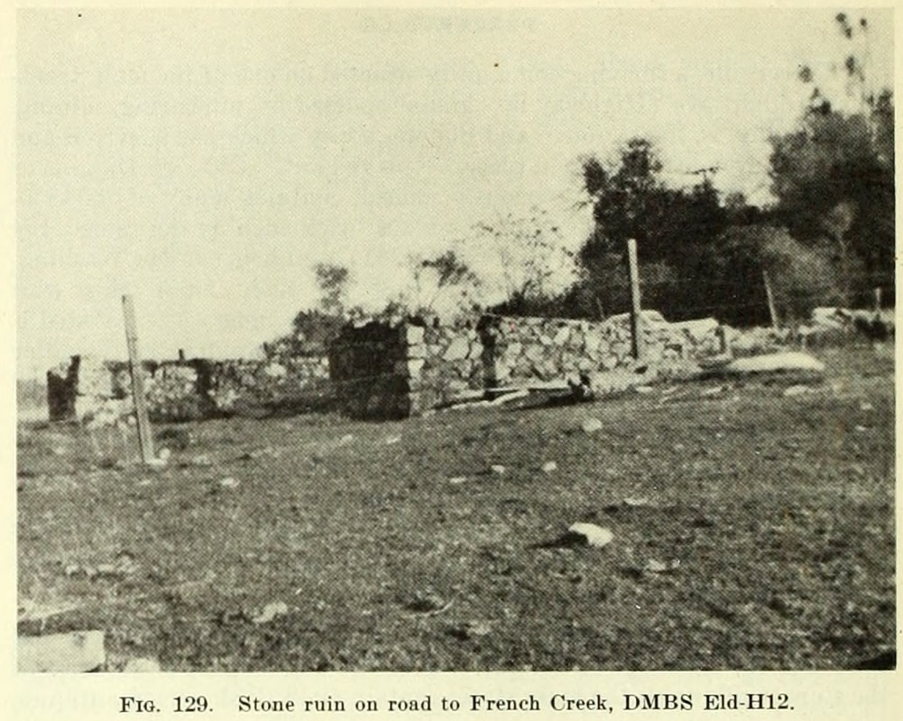
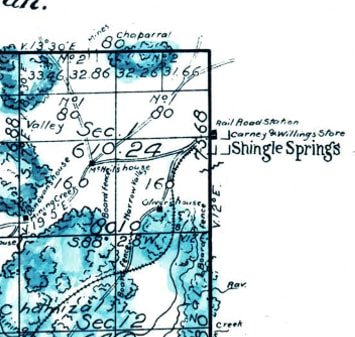
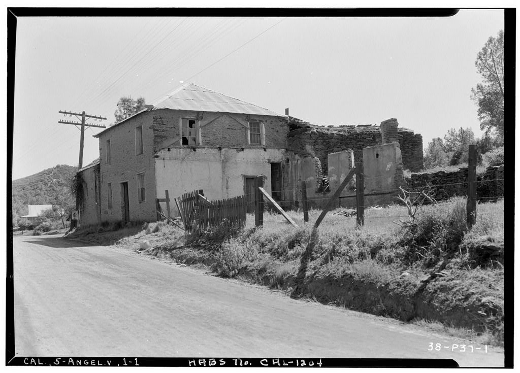
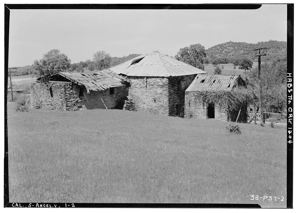
In the previous post we talked trying to find anything we could about the buildings and their possible location. I had searched General Land Office plats, USGS topos, and railroad maps from the 1850s through the 1950s but still found no definitive proof that these building even ever existed. As a reminder the 1948 Division of Mines bulletin described these buildings as being west of Shingle Springs. The first building (Fig. 128) was described as "Just west of town near the railroad crossing, a well preserved house of meta-andesite fieldstone, talc schist, and white quartz float laid with mud-lime mortar can be seen." While the second structure (Fig. 129) was south of there, just "a few hundred yards on the French Creek road are two old building ruins made of meta-andesite and serpentine." The map below is the general location of the site. Note: Lots of modern buildings, not many cool old ones.
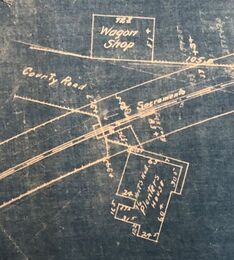
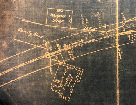
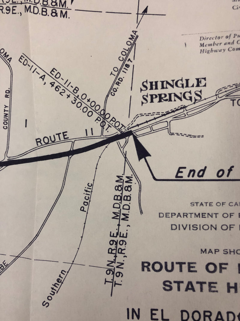
One of the last maps we looked at on the previous blog post was a 1911 map of the Southern Pacific station and rail line near Shingle Springs. As one of the buildings was close to where the railroad crossed the Placerville-Sacramento Road, I though we might find something but like the other maps it was a bust. However the following year, a new entity gave me more hope in documenting at least one of the buildings. See that "County Road" in the SP Station Plat at right? It was about to figure more prominently in the search.
I had hopes that the Highway Commission would provide a clue to the buildings because on November 18, 1912, they directed the Highway Engineer was to "cause the necessary surveys, plans and estimates be made to the portion of Route 11, beginning at Folsom and extending via Clarksville, to Placerville to connect with the State road there." Route 11 was the what would become Highway 50, and guess what it would go right through Shingle Springs on the previous Placerville-Sacramento Road. Probably great news for Shingle Springs but bad news for our buildings.
1893 Placerville Topo Map. The Placerville-Sacramento Road is shown running east-west through Shingle Springs.
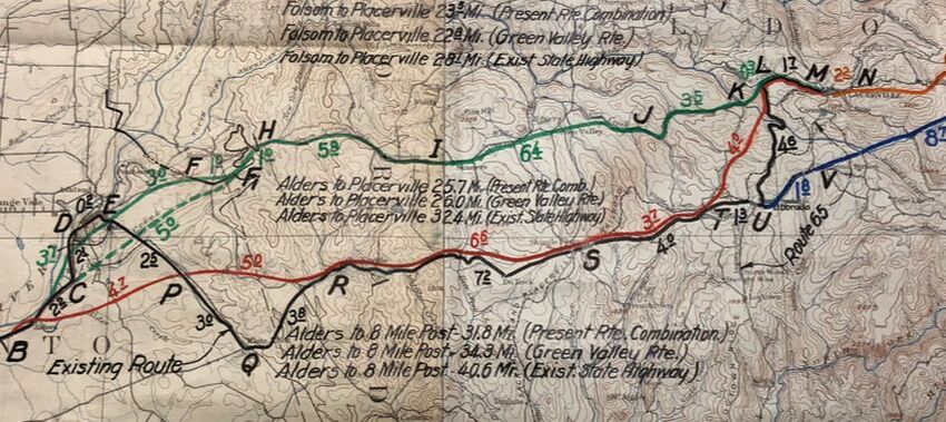
A month before the Highway Commission's vote took place, a preliminary reconnaissance report was submitted to the State Highway Engineer with a recommendation on the best route between Folsom and Placerville. The surveyor located 2 potential routes. The first went by way of Green Valley, which be north of the Placerville-Sacramento Road, and pass through the town of Rescue. This route would be exceedingly hilly necessitating a great deal of bridging but would only be a distance of 24.8 miles. The other route was would leave Folsom, pass through Clarkville, then cross rolling hills to Shingle Springs and El Dorado before crossing the problematic Webber Creek and entering Placerville. The distance was estimated as 26 miles. For the next 30 years, these 2 lines would be contested as the best route between Folsom and Placerville. The surveyor did "not hesitate to recommend the route be way of Clarkville" since it be cheaper to build and accommodate more people and towns. Score one for Shingle Springs, I guess.
With the route selected, the alignment would follow the Sacramento-Placerville Road, which was incorporated into the state highway system. The Division of Highways (today's CalTrans) now began looking to improve the road. In February 1916 another preliminary report was submitted on the route between Shingle Springs and the Sacramento County line. The report came close to giving us some information about Fig. 128, the railroad crossing building. Near the crossing, the report noted that there was an obstruction but that was the old Planters Hotel not our building. Still looking for a clue as the site of this building.
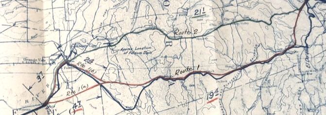
Those people in Rescue though would not give up on having the route altered to travel through their part of the county. They again agitated for a new routing through Green Valley as it would be shorter and more scenic. The Division of Highway noticed their efforts because a few years later a new survey of Route 11 was undertaken by the Division. A 1932 report on finding a permanent route from Sacramento to Placerville included the map above, with a strong nudge towards Route 2 which would bypass Shingle Springs. This came after a 1930 recon report that also noted that the most feasible route would be through Green Valley since it was shorter and had a better alignment. So close to moving the road north, however the original route persisted.
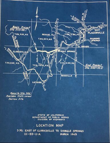
A follow-up report was completed in 1938 with additional information about traffic (it was really increasing) and economics (it costs a lot to build an entirely new road). They finally settled on the upgrading the existing route. In the map below, they recommended the E P R S T L M alignment.
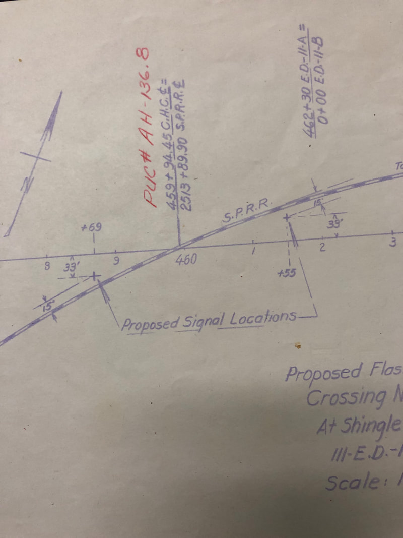
Okay, why is this all important? What's the big deal with the Green Valley route? Why do I care that the Division of Highway's didn't change the route despite plenty of instances to do so. Because if they had re-routed Highway 50 to the Green Valley alignment, then one, if not both, of the buildings may have been saved. By keeping the highway going through Shingle Springs and the Division of Highways and CalTrans continued to try to improve it though re-aligns and relocations. I think that at some point this lead directly or indirectly to the destruction of the building(s). Don't believe me. Take a look at these sketches of proposed re-alignments from the 1940s and 1950s. At some point these buildings didn't stand a chance. In particular the image below left was from a proposed 1953 relocation of the highway. Lots of road work right through the area of our concern. I believe that at the latest the end came in the early 1960s when the highway was moved to it present location a few hundred feet north of the old highway through Shingle Springs.
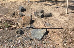
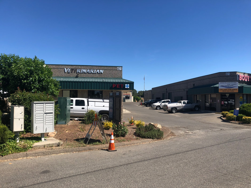
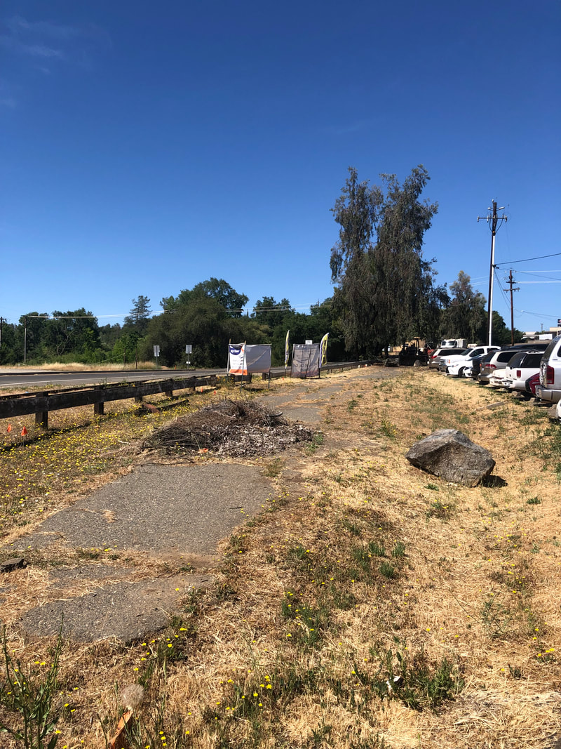
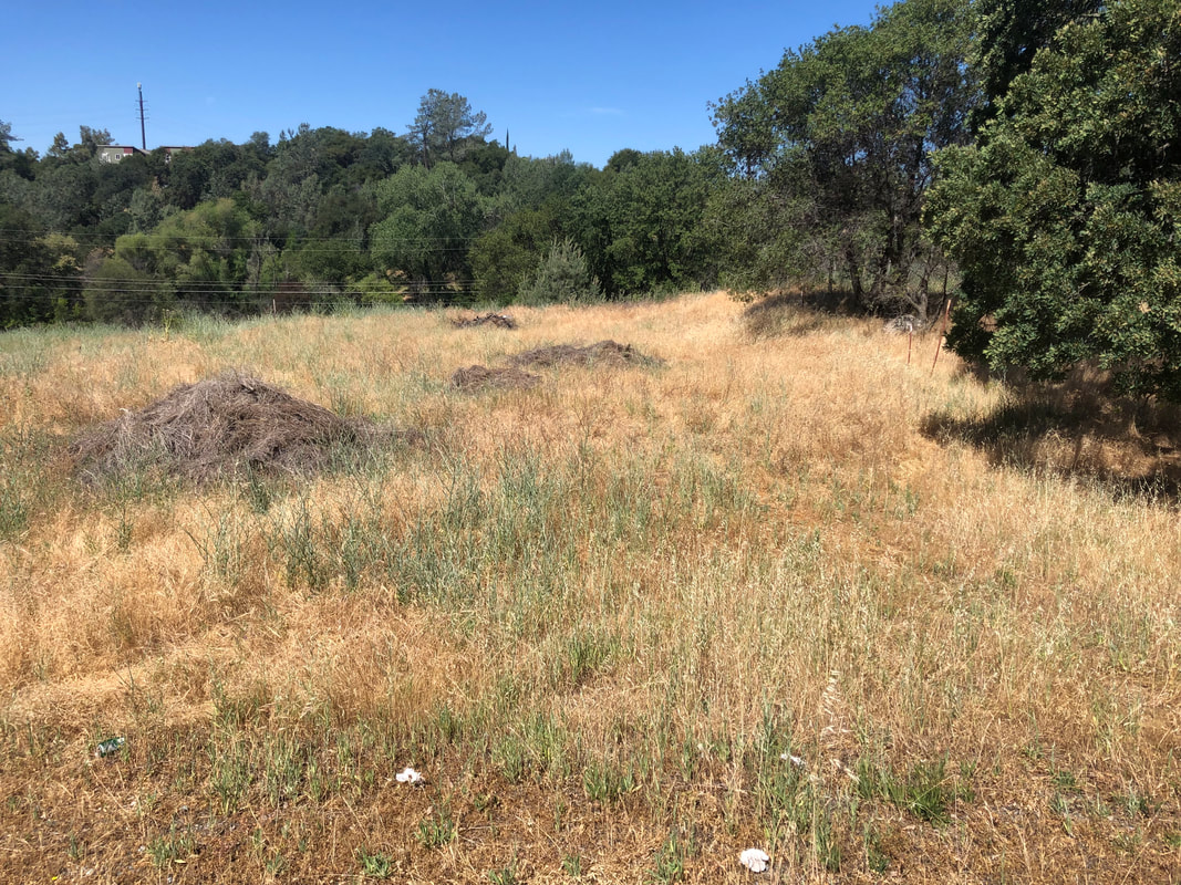
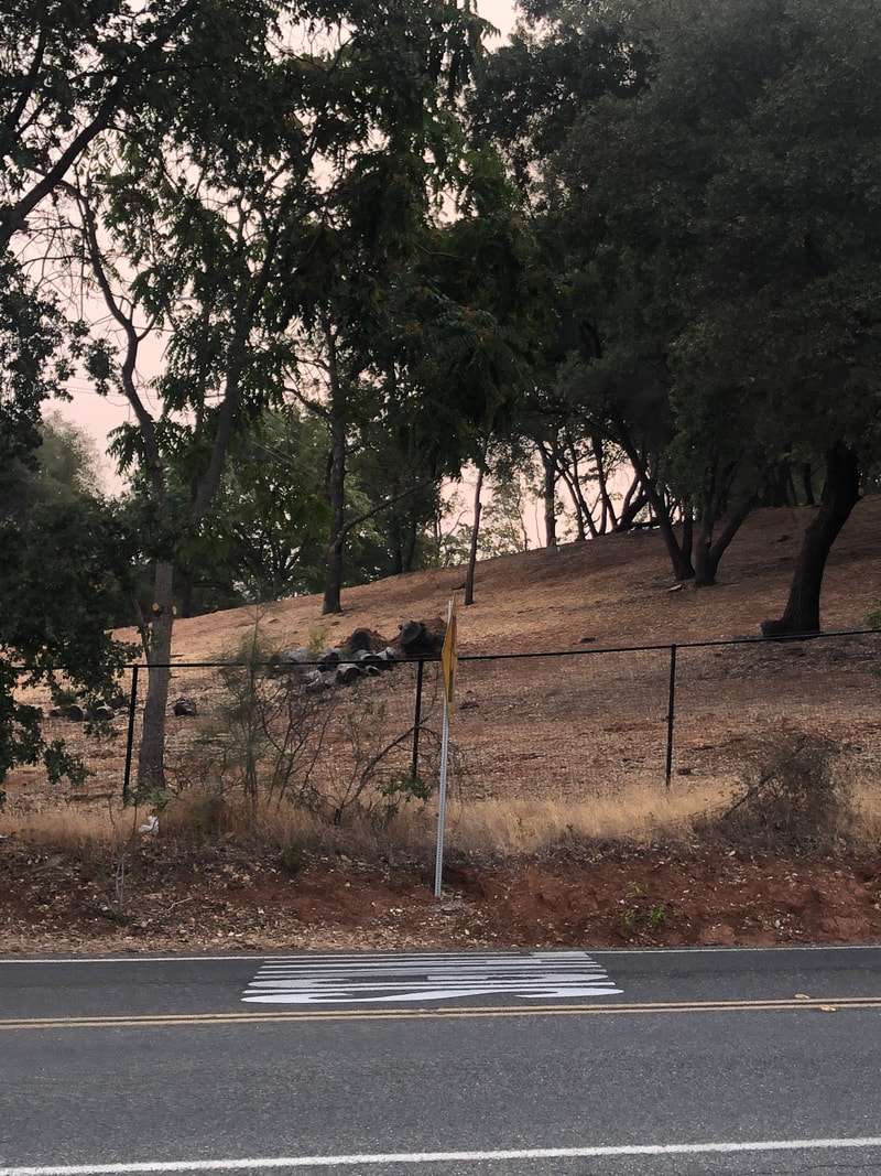
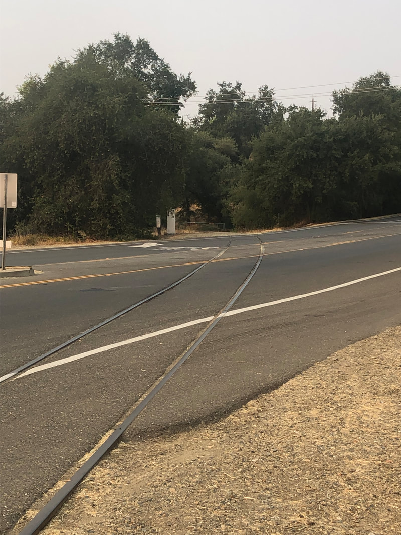
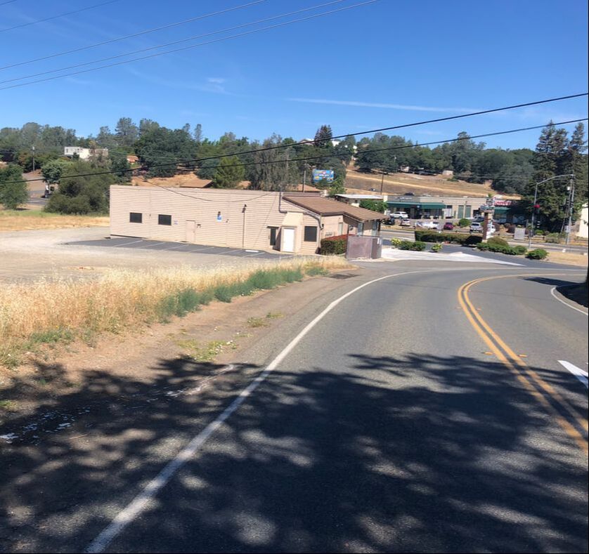
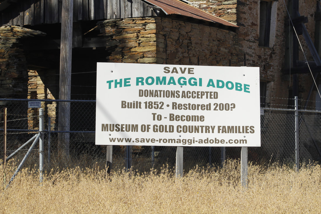
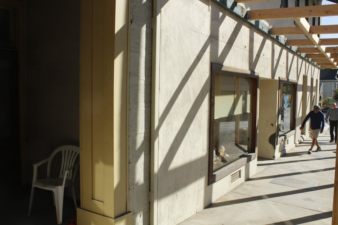
So how did I do, teach? Does my work check out? I wish there was a better answer to my questions about these buildings. As always at least I got to make a nice drive to the foothills for this project. The best I was able to do on one of visits was to get a picture of these rocks near the railroad crossing and the old highway. Maybe they could have been from one of the buildings? Maybe? So what sits at the site today. Check out these photos below.
And how about a "few hundred feet (south) on French Town road"? Definitely not an old stone buildings.
1 Comment
Visit Dates: May 31, 2021 & August 15, 2021
This post is a week late. Sorry. Please excuse the work in progress. Here is the thing. I just can't figure out if these two buildings still exists, where they were located, or when/if they might have been destroyed. Figuring out these details is absolutely locking me up. Maybe if we didn't have Covid, and if I was retired, and if I had time to visit the State Library and El Dorado County Archives, then maybe I could feel like I've exhausted all my resources. As it is here is my best attempt to document the sad story of these two buildings located just west of Shingle Springs in El Dorado County.
This post is a double double dip. First, it's part one of a two-part discussion. Also its about not one but two sites from the 1948 Division of Mines building survey, although their story and my research are so similar that I've chosen to combine them. The first building (Fig. 128) was described in the survey as "Just west of town near the railroad crossing, a well preserved house of meta-andesite fieldstone, talc schist, and white quartz float laid with mud-lime mortar can be seen." While the second structure (Fig. 129) was south of there, just "a few hundred yards on the French Creek road are two old building ruins made of meta-andesite and serpentine." So there were a few clues to the location: west of Shingle Springs, near the railroad crossings (Fig. 128), and a few hundred yards south on the French Creek Road (Fig. 129). So let's take a look at what that looks like today.
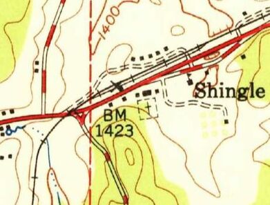
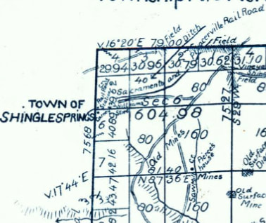
In the map above, the railroad crosses the old highway roughly at the "M" in Mother Lode Drive. Fig. 129 was probably located somewhat near that vicinity. My google map search, drive-by windshield survey, and field work on the ground recon (I walked around) on both sides of the road, though left me still searching for Fig. 128. A similar search along French Creek Road revealed nothing as well. Fig. 129 was probably somewhat near the words "French Creek Road," which is about 600 feet south of the intersection with Mother Lode Road.
So where are these buildings? Sadly, I feel comfortable in saying that they have not survived the nearly 75 years since the Division of Mines building survey. It's likely that their deteriorating condition as seen in the original photos above and the location near the old route of Highway 50 were their downfall.
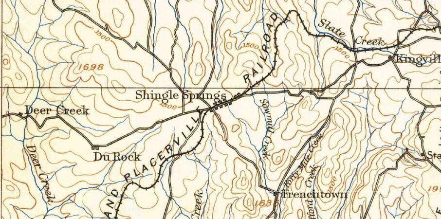
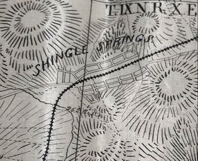
 Shingle Springs Quadrant, 7.5 Minute Series, 1950 Shingle Springs Quadrant, 7.5 Minute Series, 1950
In the late 1940s and early 1950s the US Geological Survey released many of their 7.5 minute series maps for the Gold Rush Country. These maps are really really helpful in determining what might have been on the ground at that time, including existing buildings and the routes of the roads and highways at that time. At left is the 1950 Shingle Springs map. French Creek Road is the line running south below (BM 1423), while the railroad crossing is shown to the left of BM 1423. The map shows no showing buildings in the places you would expect our buildings to be based on their description. Note: the road running east-west through Shingle Springs was Highway 50, which is now routed about 200 yards north of the Mother Lode Road (Old Highway 50).

A less detailed map than the one above was a Placerville plat originally drawn in 1893 and updated in 1947 by the USGS. This map does suggest that possibly one of our buildings was on the southwest corner of French Creek Road and the Mother Lode Road. Mother Lode Road was known as the Sacramento and Placerville Road at the time the map was drawn. The scale of this map was such that it is difficult to know if the shown building is merely a representation of Shingle Springs or the location of an actual building, let alone one of our buildings.
The 1950 map above shows a dotted line running north-south close to our area of interest. This line is the General Land Office survey line between section 1, Range 9 East, Township 9 North and Section 6, Range 10 East, Township 9 North, Mount Diablo Meridian. The surveys of these lines were done in the 1850s and 1860s, and I hoped the plats would possibly show either of our buildings due to the date of buildings and location of the survey.
It was lucky that the surveys went directly through Shingle Springs, but you can see that neither of the plats show any structures to the west of town. The plat on the left would have been the one most likely to have shown one of the buildings. All hope though was not lost. The surveyors also include field notes for their land survey. Maybe they would mention some features not shown on the map. The field notes for section 1, T9N, R9E held the most hope.
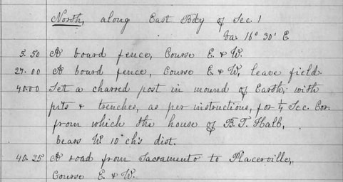
Surveyor David Douglass's notes from his March 1859 survey provide one of the few potential details of one of our buildings that I could find. On page 27 of his field book, Douglass noted features he came across as he moved north along the line between Townships 9 and 10. At 5.50 chains north of corner between sections 1 and 2, he found "A board fence" running east-west, and at 27 chains he crossed a similar fence, but at 40.00 chains he put a charred post in the ground for a quarter section corner, "from which the house of B.T. Hall, bears W(est) 10 ch(ain)s dist(ance)." And then at 40.25 chains he came upon "A road from Sacramento to Placerville, Course E.&W." (A chain length is 66 feet.) So according to the surveyor there was a house south of Shingle Springs and about 650 feet to the west that existed in 1859. I wish there were more details about B.T. Hall's house, which could easily have been building in Fig. 128. (Yes, I know. I know. It is a long shot, but conformation bias is my religion.)
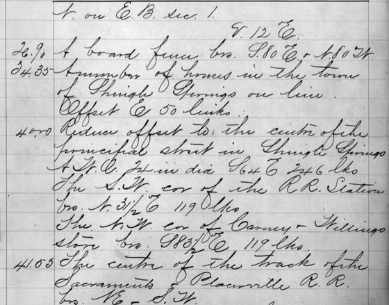
A similar survey was run in the spring of 1865 by James Freeman. Freeman also headed north along the same line. At 34.35 chains he found "A number of houses in the town of Shingle Springs on line." At 40.00 chains he reached the center of principal street through Shingle Springs. So roughly 400 feet south of Shingle Springs were a number of houses. I'm going to speculated (hope really) that one of these was the stone building in Fig. 129.
So by 1865 the railroad ran through Placerville. Maybe that was something I could use. The Placerville and Sacramento Valley Railroad was surveyed in 1865 and filed a map of their line with the Secretary of State in 1867. The map has a lot of detail, just not any of the ones that I needed. While it shows the town of Shingle Springs, even its streets; there were no buildings found along their alignment. Like Gob says, "Come On!"
Okay, let's not give up on the railroad angle. In 1911 the state Railroad Commission required all the railroads in the state to submit alignments and profiles of their lines, as well as the plats of their stations. No doubt this would have the information needed to identify at least one of these buildings, in particular Fig. 128, which was near the railroad crossing. So let's take a look.
By 1911, the Southern Pacific Railroad had purchased the line. But when it came time to submit the station plat the only one on hand was a blueprint from 1898. Unfortunately our buildings were not close enough or significant to to show up on the plat, although they did draw a few structures near the railroad-county road crossing.
The alignment of the entire line would also have to show the area west of Shingle Springs. So there was a chance we might be a glimpse of the buildings, or may have a good clue. These buildings though are elusive, so guess what. The map furthered my frustrating search as you can see in this map below. Lots of detail about deeded lands but not about structures sitting near railroad line. No wonder no one liked the SPRR.
In the next post we'll conclude with a dive into the highway construction and alignment and how a different routing might have saved 2 old stone buildings.
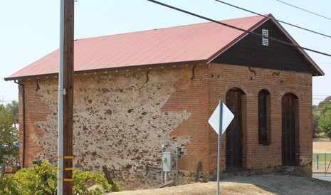
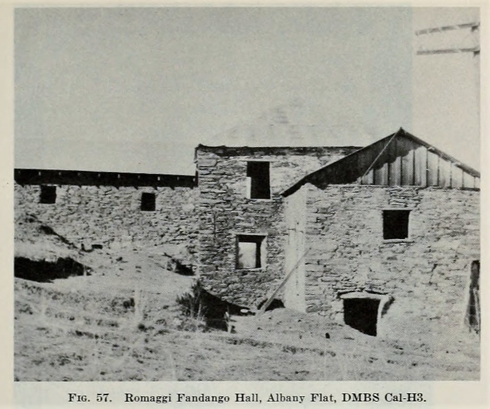
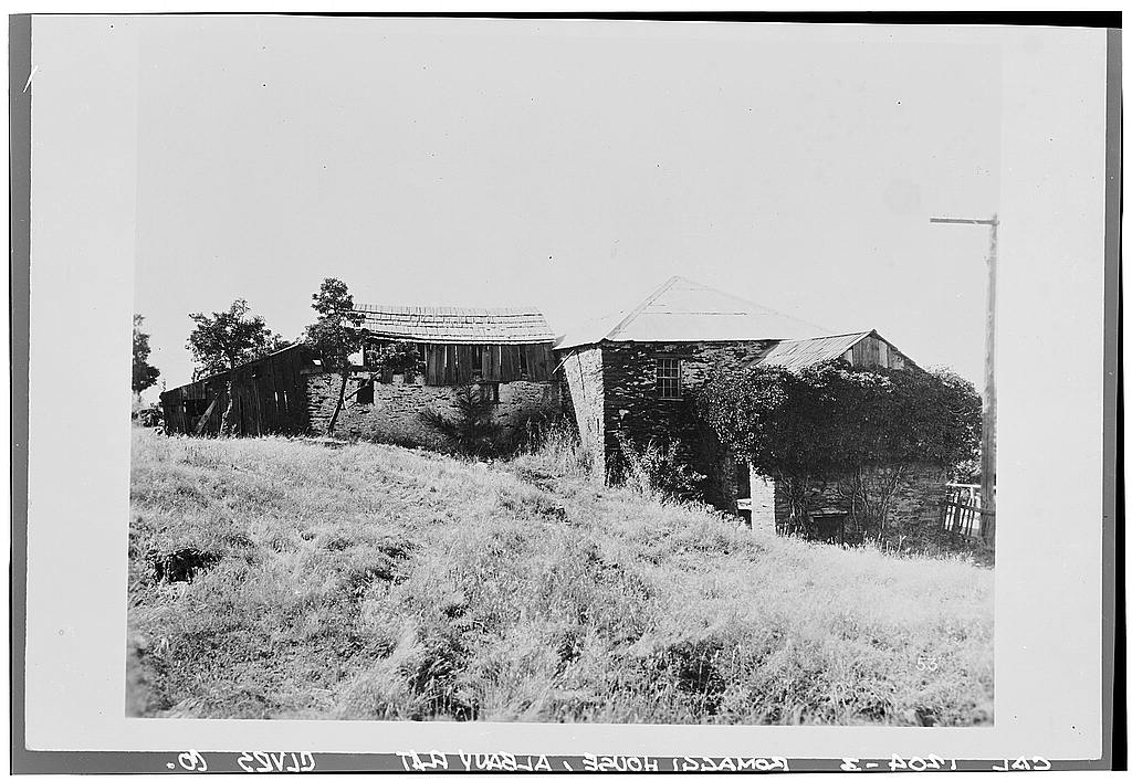
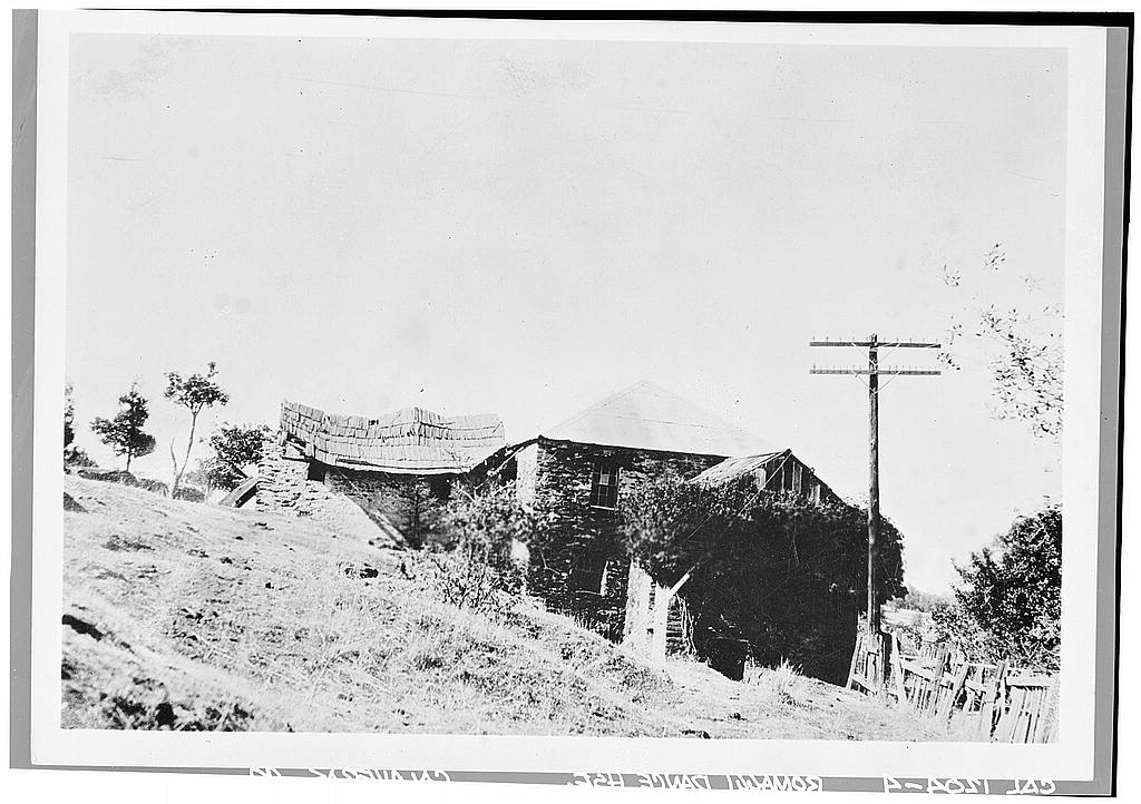
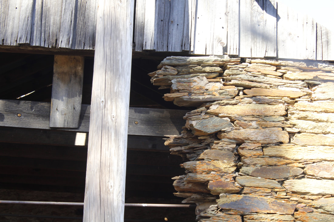
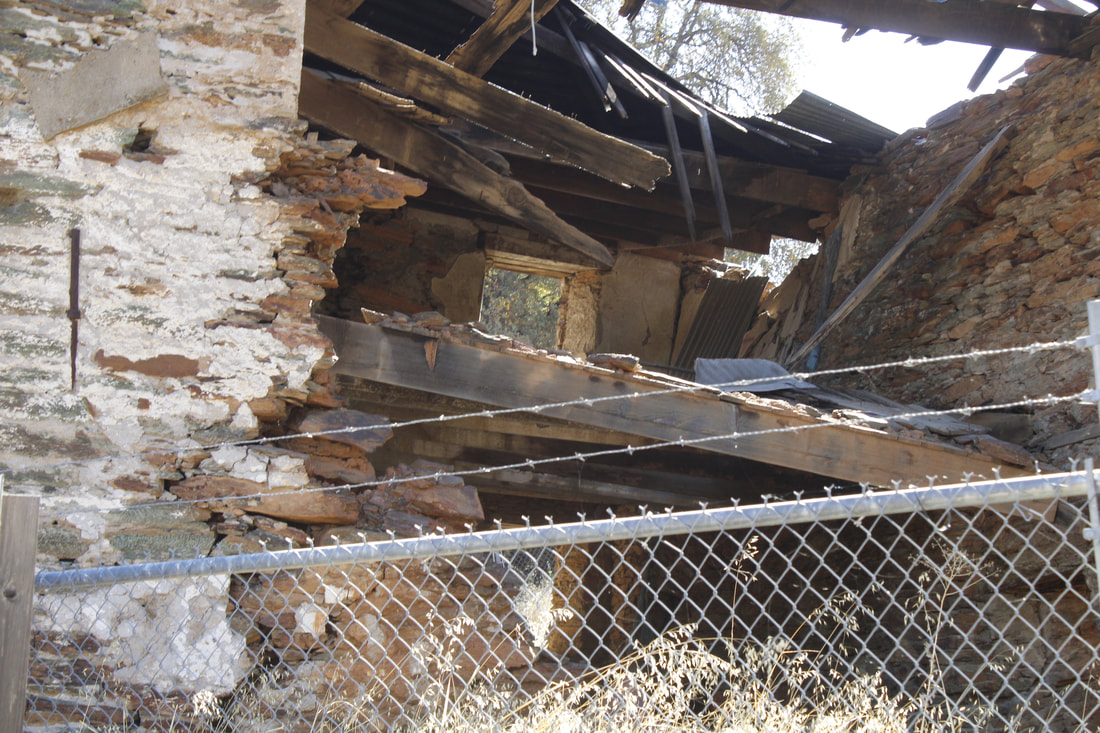
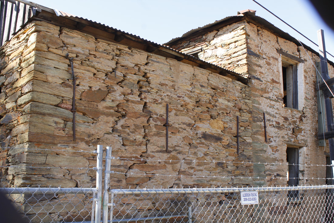
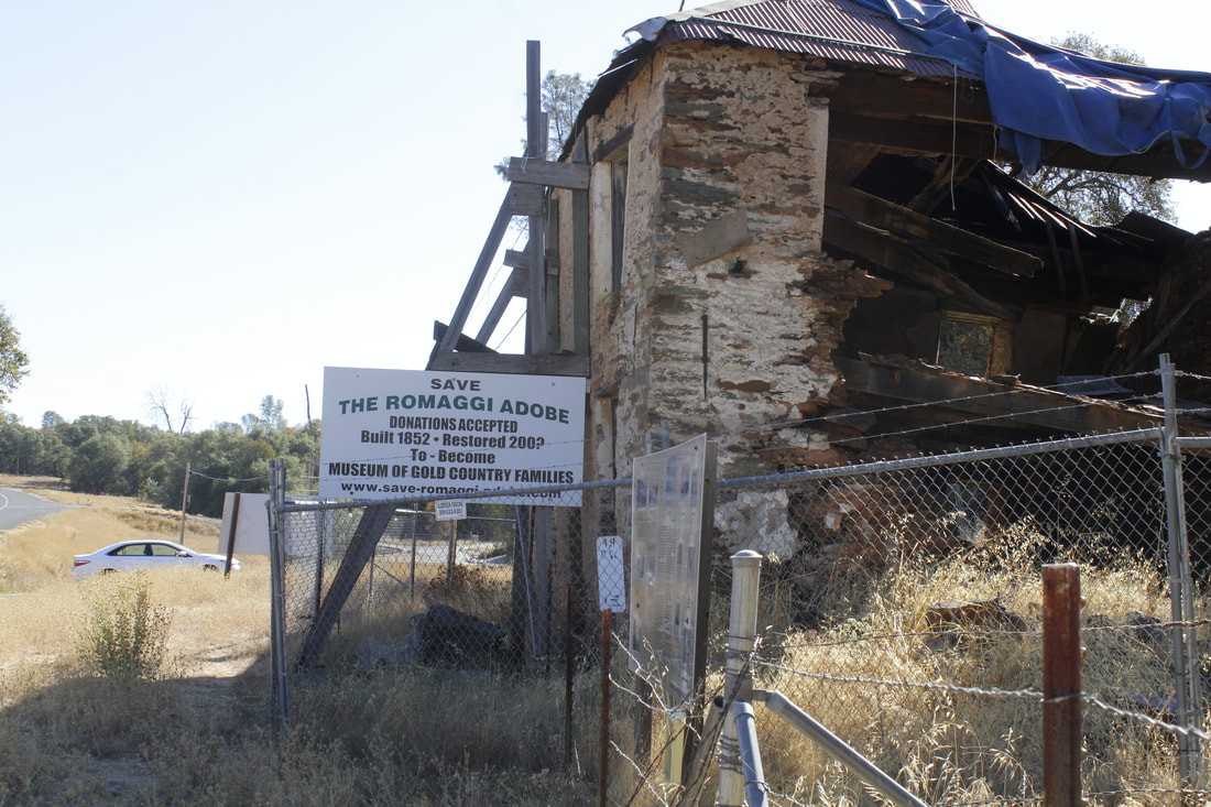
Visit Date: November 9, 2019In a previous post, I discussed the amazing day I had visiting the Angels Hotel in Angels Camp. The day was fantastic but not all of the buildings I saw that day were. The Angels Hotel is still in superb conditions, still being used as an active business as well as having an owner who is actively maintaining it. In contrast, just prior to photographing the hotel, I visited a structure in absolute dire need of repair, if that is even possible at this point. The Romaggi Fandango Hall in Albany Flat, Calaveras County needs help now! 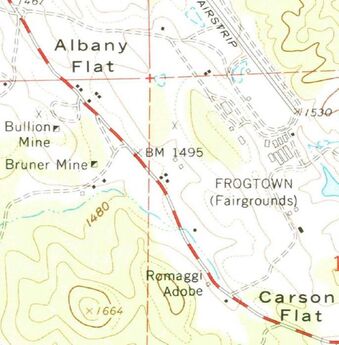 USGS 1:24000-scale Quadrangle for Angels Camp, CA 1962, photoinspected 1973 USGS 1:24000-scale Quadrangle for Angels Camp, CA 1962, photoinspected 1973 The Romaggi Fandango Hall was been in a state of disrepair for many years. The building seems to have really suffered since 1948 when the Heizer and Fenanga in their Highway 49 building survey wrote that "Few buildings in the entire Mother Lode can match this for size, excellence of construction, and elaborateness." However by 1961, one historian noted that the while walls of the main building were still solid, the side walls were in ruins. The structure though was still notable enough that it was specifically identified on the 1962 USGS Angels Camp topographical map. It's actually surprising that the building even still stands. In the 1930s the Historic American Buildings Survey visited and documented the "James Romaggi Fandango House". The photos from this survey are available online from the Library of Congress. Those photos are shown below. Note the condition of the roof in these photos, but more importantly, look how close to Highway 49 the building sat. How did someone not plow into the house after after having a few too many on a Friday night?
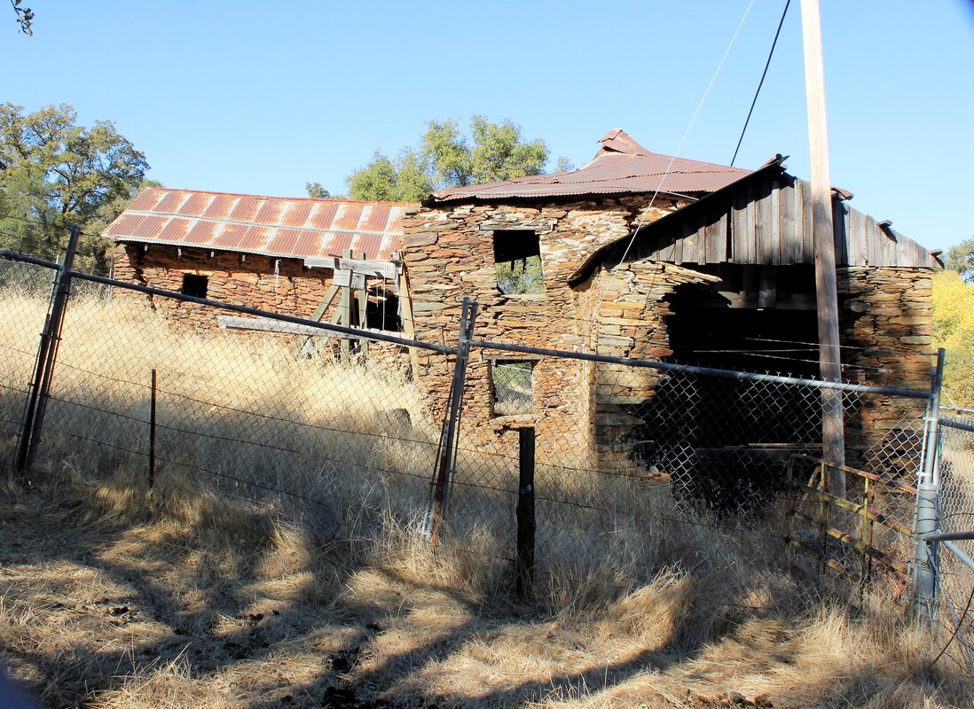
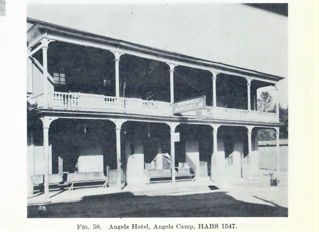
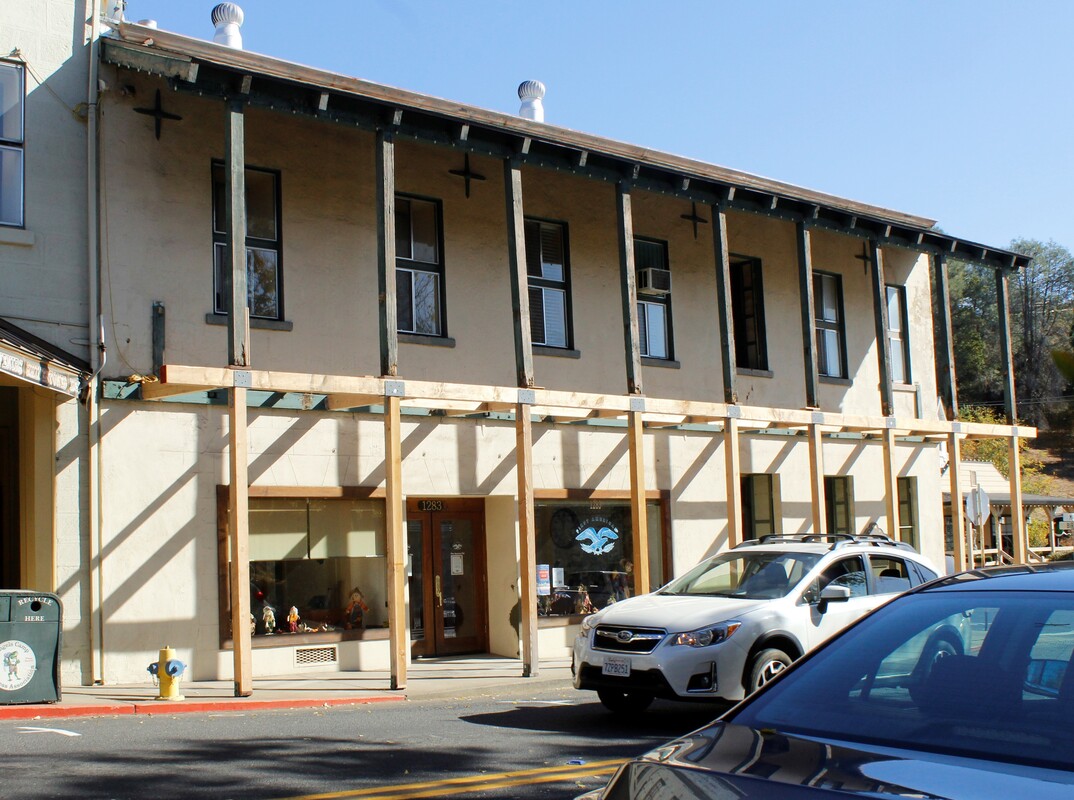
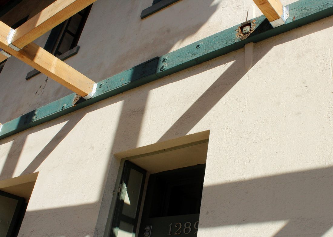
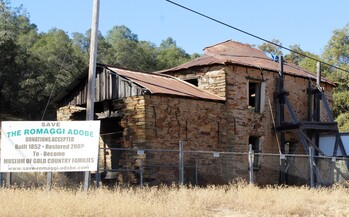 Every passing year without repair makes the job of saving the building that much more difficult. As you can see in these 2019 photos. I do hope that they are able to save the building. I just don't want to get to the point where I say that I am happy I visited in 2019 because it no longer stands. Too many of these building save disappeared already. I wish this building had the love of the Angels Hotel. Site Visit: November 9, 2019Have you ever had a really great day? Everything seems to go just right. People are nicer. The food tastes better. The weather is ideal. Well, the day I made this visit was that type of day. I like any day I get to drive through the Gold Country, but this was better than most. I headed first for the Calaveras County Fairgrounds (where they annually hold the best named county fair, Calaveras County Fair & Jumping Frog Jubilee!) to see my son complete in the high school cross country sectional finals. While the day didn't go too well for him that morning, after a really nice deli lunch I was left with all afternoon to track down old buildings, including the Angels Hotel, Angels Camp, Calaveras County. This building is fortunate. It has an owner who is continuing to care for it. During my visit, the building was in the middle of having a new façade added to it. It seems that only a few years of neglect, deferred maintenance, or even mild disinterest is the death knell to these buildings. Once they start to deteriorate, it's so hard to reverse the process by doing the needed repairs and maintenance, while keeping their historic character. 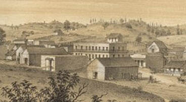 By selecting to write about this building, I believe am required to inform you that during a visit to the hotel in the 1860s, Mark Twain he first heard the story that he would go onto write as "The Celebrated Jumping Frog of Calaveras County. Needless to say, the building is old. Starting as a simple wooden structure erected in 1851, by 1857 it was re-constructed as a two story building which is partially obscured in the center of this 1857 bird's eye view drawing of Angels Camp. I think this is the oldest image I have found of one of the buildings from the 1848 Building Structures Survey. 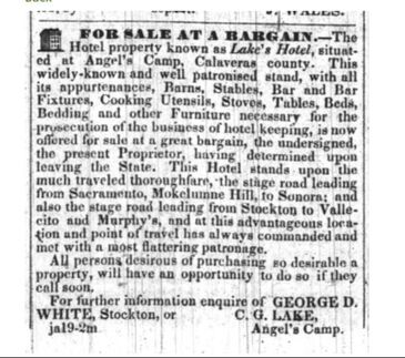 San Joaquin Republican, January 27, 1855 San Joaquin Republican, January 27, 1855 In the 1850s, the building was known as Lake's Hotel. C.C. Lake though wasn't completely sold on the idea of running a waystation. In 1855, prior to re-building as a stone structure, he put the operation up for sale and planned to leave the state. I guess he couldn't find any suitors for "so desirable a property", because a year later he hosted the New Year's Ball, which celebrated the opening of "his new Stone Hotel". 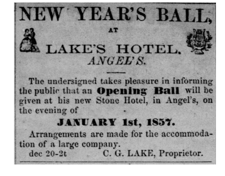 Stockton Independent, December 20, 1856 The day was amazing but it wasn't perfect. Trying to get a clear view of a building when shooting across Highway 49 was a real challenge. Check out all these people who had no idea that they were going to end up on the internet when they got in their cars that day. |
AuthorMy name is Jeff and I am on a hunt to find historic brick and stone structures along Highway 49. Archives
January 2022
Categories
All
|
 RSS Feed
